From the pristine Tirino Valley to the towering heights of Gran Sasso: an eco-sustainable itinerary in one of Italy’s most picturesque corners.
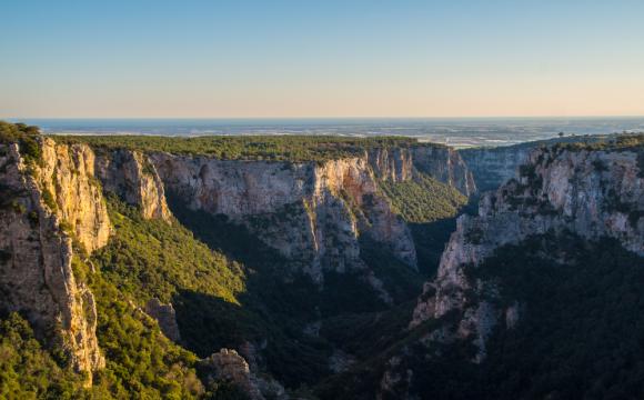
Known as the “Silent Giant”, the dramatic 3,000-meter (9,000-foot) peaks of Gran Sasso have long been a symbol of the region of Abruzzo and star of the sprawling Gran Sasso and Laga Mountains National Park. For centuries, the unforgiving slopes and plains of the highest massif in the Apennines have hosted little more than tiny alpine hamlets and flocks of sheep so vast that they formed the backbone of the Medici family fortune, which began with the wool trade during the early Renaissance. Today, these rugged summits attract adventure seekers from across the globe, eager to take on its challenging trails with the promise of views that stretch as far as the Adriatic coast.
Gran Sasso and the seaside towns along the coastline below are by far the two most popular attractions in Abruzzo, thick with summer visitors who want to avoid the high-season crowds of Italy’s more famous regions but still enjoy the Bel Paese’s famed hospitality and cuisine. Tucked between the mountains and coast, however, are a wealth of stunning landscapes, captivating hilltop villages, and unforgettable local dishes that tell the story of this rustic region’s history and culture but remain largely unknown and set far from the tourist melee.

Dubbed the “land of saints and warriors”, these hills and valleys beckon with an authenticity born of centuries of isolation, where you can enjoy the best of sustainable tourism while floating down crystalline rivers by canoe, admiring vineyards and pastures by bike or horseback, and relaxing in small, family-run B&Bs and restaurants.
The new 100-kilometer (60-mile) “From Tirino to Gran Sasso: Lands of Saints and Warriors” route—part of the nine Emblematic Mediterranean Mountains eco-itineraries across Mediterranean peaks from Spain to Greece—makes it easier to access this swathe of Abruzzo that includes the Tirino Valley and Lands of Baronia, as well as connect with local guides and hosts.
The itinerary sets off from the banks of the Tirino River and gradually climbs the slopes of the Apennines to the high plateau of Campo Imperiale before making its way back down through the saffron fields of Navelli to the Capestrano, home to the enigmatic Capestrano warrior statue dating from the 6th century BC. The route is divided into 8 stages, and you can take on the entire length or just a portion.
Whether you spend more than a week taking a deep dive into Abruzzo or dedicate just a few days to exploring the route, you’ll be taken by the unparalleled views and unique history of this enigmatic land.
The Land of Saints and Warriors
The Tirino Valley, Ofena, and Villa Santa Lucia degli Abruzzi
The route begins in the Tirino Valley, where the Tirino River is fed by the spring waters of Lake Capodacqua and flows past holm oak woods, vineyards, olive groves, and lush fields. Considered one of the most beautiful rivers in Europe, the Tirino is a popular spot to canoe and kayak, and the valley can be explored by bike or on horseback. From the hamlet of Capo d’Acqua, the route follows the ancient Roman Via Claudia past the Abbey of San Giacomo and fortified village of Ofena before arriving in the town of Villa Santa Lucia degli Abruzzi, home to the Church of Madonna delle Vicenne and its 17th-century fresco.

How to explore: By far the best way to explore this stretch of the route is by floating down the Tirino River via canoe or kayak. Il Bosso is an excellent local outfitter that leads guided river excursions, and also e-bike tours along the valley. To explore on horseback, contact Auriga for guided horseback riding tours.
Local specialties: Much of the area’s wine and olive oil production is centered around this valley, which has a relatively mild microclimate. Stop at the Cataldi Madonna winery to sample Montepulciano di Abruzzo, Pecorino, and Trebbiano wines.
Don’t miss: Unique highlights along the route include the ancient stone “tholos” dwellings, probably dating to Roman time, and the Marmitte Caves near Ofena, considered sacred during the Neolithic period.
Villa Santa Lucia degli Abruzzi to Castel del Monte
Much of the second stage follows historic routes used by shepherds over the centuries to move their flocks between the high and low plains to pasture, according to the season. This tradition, known as the “transumanza”, is one of the hallmarks of Abruzzo’s rural culture and continues still today, though on a much smaller scale. The route takes off from Villa Santa Lucia to skirt Ofena and climb the mountain slopes to Castel del Monte, one of the most picturesque hilltop villages in Abruzzo. Above the village sits the ruins of the former castle, accessible only on foot, and today home to a number of artisan workshops and art studios.

How to explore: This path is not well marked, so you may want to explore with a hiking guide to avoid the hassle of trying to navigate stretches of trail and country road on your own. Il Bosso (see above) offers guided hikes and excursions along this and other route stages.
Local specialties: Castel del Monte’s canestrato sheep cheese is a Slow Food certified specialty and symbol of the traditional “transumanza”. Today, most sheep are housed in barns in the valley over the winter, but the historic canestrato pecorino cheese remains one of the delicacies of the area, aged for two to twenty-four months in wicker baskets known as “fuscelle” that give it a unique surface texture.
Don’t miss: On the night between August 17th and 18th, Castel del Monte celebrates the “Night of the Witches”. Harking back to historic legends and lore, the all-night festival centers around the retelling of the stories of Francesco Giuliani, a shepherd and poet who recorded the area’s most popular fables of witches and magic.
Castel del Monte to Lake Racollo
Perhaps the most scenic stage of the route, this leg takes you from Castel del Monte along the slopes of Mount Bolza and past the Valianara Canyon, also known as Scoppaturo, to Lake Racollo. Along the way, you’ll be treated to your first views of Campo Imperatore, the highest plateau in the Apennines ringed by the peaks of Corno Grande, Mount Brancastello, Mount Prena, and Mount Camicia. The plateau is home to vast stretches of pasture where herds of sheep and cows spend most of the summer months, as well as a number of roadside eateries and alpine chalets offering rooms and meals.

How to explore: Hiking and walking the upper plains of Gran Sasso is not for the inexperienced, so explore with an expert local guide for a safe and fun day on the mountain. To overnight on the high plain before continuing on along the route the following morning, book at the Lake Racollo Refuge.
Local specialties: Campo Imperatore is dotted with a handful of roadside stands selling “arrosticini”, or bite-sized cubes of mutton skewered on wooden kebabs and grilled over wood coals. One of the mainstays of Abruzzo’s regional cuisine, arrosticini are eaten by hand straight off the grill.
Don’t miss: The landscape of Campo Imperatore is one of the most striking in Italy, and the high plateau has served as backdrop to a number of films from the spaghetti westerns of Sergio Leone to “The Name of the Rose”. Be sure to bring a good camera or powerful smartphone with you to capture its stark drama.
Lake Racollo to Rocca Calascio and Calascio
From Racollo, this stage circles the Campo Imperiale plateau along the western edge, passing Lake Passaneta with views over the peaks of Mounts Camicia, Prena, and Bolza. From here, you’ll arrive at postcard-perfect Santo Stefano di Sessanio, thick with artisan shops, restaurants, and one of Italy’s first and most popular “alberghi diffusi”, or hotels spread among historic homes across the entire hamlet. You may be tempted to stop here for the night, but press on to Rocca Calascio, the highest fortified village in Italy. This outpost was used by the Medici family to oversee the “transumanza” and wool trade in the surrounding villages, and was once home to elegant palazzi and baroque churches. A series of earthquakes has left the fortress a picturesque ruin, while the charming village of Calascio just below still buzzes with life.

How to explore: At 15 kilometers (9 miles), this is one of the longest stages of the itinerary and best taken on with a hiking or biking guide; an e-bike is an especially pleasant way to explore and Escursioni da Paura offers guided biking tours. For something a little different, you can also take on part or all of the route via donkey with Gira e Rigira. Santo Stefano and Calascio offer a variety of options for dining and overnighting.
Local specialties: Santo Stefano di Sessanio is home to a number of the most popular traditional restaurants in the area, where it's easy to sample a variety of specialties grown and produced in the Gran Sasso park and surrounding areas. If you are planning on splurging on one special meal, this is where you’ll want to do it.
Don’t miss: The village of Calascio is home to three historic churches: the 15th-century San Nicola di Bari; Madonna delle Grazie, with sculptures dating from the 16th century; and San Leonardo, located just outside of town and built in 1263.
Rocca Calascio, Castelvecchio Calvisio, and Santo Stefano di Sessanio
Today’s leg takes a deep dive into the hills between Rocca Calascio and Santo Stefano, with plenty to keep gourmands happy along the way. From Rocca Calascio, the route winds downhill to the medieval town of Castelvecchio Calvisio, a fortified town that has roots in ancient Rome, and the nearby village of Carapelle Calvisio. Both take their name from Calvisia, the ancient priestess that once guarded the temple dedicated to Venus located on these mountain slopes, and this entire area is known as the “barony of Venus” and was once part of first the Piccolomini dynasty before passing into the hands of the Medici family.
How to explore: Like the previous leg, today is a long route covering around 18 kilometers (11 miles) and is best taken on with the help of a hiking or biking guide. An easy way to arrange for a guide and/or outfitter is by contacting the Punto Informativo Gran Sasso and Monti della Laga office in Santo Stefano.
Local specialties: Carapelle Calvisio is considered the center of this area’s olive oil production, and there are a number of mills still active. Stop by the Antonacci family “frantoio” in the autumn months to see how oil is produced and sample freshly-pressed extra-virgin olive oil. There are also a number of heirloom legumes grown on these high-altitude slopes, including “cicerchie” (a cross between a lentil and a chickpea) and Santo Stefano lentils, a tiny, dark version which is Slow Food certified.
Don’t miss: Keep your eyes peeled while exploring the historic center of Santo Stefano for the Medici coat of arms adorning the main city gate and a number of doorways lining Via della Chiesa.
Santo Stefano di Sessanio to Barisciano
This stage skirts the hillsides from Santo Stefano past the waters of Lago della Madonna and through oak and pine groves above fields of wheat, lentils, saffron flowers, and almond groves covering the valley floor to the Piano Locce high plain. The trail then begins to descend into the Cupa Valley beneath the peak of Mount Selva, passing the Monastery of San Colombo—today a hotel and botanical research center dedicated to the Apennine flora—before reaching the village of Barisciano, a medieval hamlet near the Via Claudia with roots in ancient Rome.
How to explore: Arrange for a hiking or biking guide for this leg, which is not particularly taxing but does follow a series of unmarked roads and trails that can be rather hard to follow for the uninitiated. Contact the Punto Informativo Gran Sasso and Monti della Laga office in Santo Stefano for reliable local guides.
Local specialties: This area is known for its high-altitude potato production, and each year the Potato Festival is held in Barisciano during the final week of August to cap off the summer holidays. The most famous dish is “baccalà con patate” (cod with potatoes), said to be prepared according to a secret local recipe.
Don’t miss: The deconsecrated Church of the Holy Trinity today houses a museum dedicated to the history and culture of the transumanza, offering a uniquely moving glimpse of this grueling way of life that once dominated these mountain peaks.
Barisciano, San Pio delle Camere, Navelli
One of the most straightforward (and lengthy) legs, today’s route takes you directly southeast along the historic “tratturo magno”, or sheep path, that was once used to transport herds from the city of L’Aquila to Foggia in Puglia. At the castle of San Pio delle Camere, the path crossed the “tratturo centerelle”, which ran parallel but further inland, making it one of the most important merchant crossroads in Abruzzo for centuries. Today, this stretch of the tratturo magno is a sleepy country trail that leads to Navelli, famous for its prized saffron flowers.
How to explore: Though this stage stretches almost 20 kilometers (12 miles), the route is relatively well-marked and easy to follow. That said, insights into the history and economics of the transumanza are particularly important to understanding the area’s geography, so consider a guided hike to fully appreciate the villages and landmarks along the way.
Local specialties: Navelli is home to one of Abruzzo’s most expensive local products: saffron. Known as “Abruzzo’s gold”, this prized spice is collected from the flowers of crocus flowers that bloom in the high plains in October and November. The flowers were introduced into the area in the 13th century by the Domenican monk Santucci di Navelli, who brought them back from Spain. For centuries, the saffron produced here was strictly for export and not used by locals for cooking.
Don’t miss: Just outside Navelli, the tiny village of Civitaretenga is a medieval gem. Stroll through to admire the Church and monastery of Sant’Antonio and the central church of Sant'Egidio with its soaring watchtower.
Navelli to Capestrano
From land of saints, scattered with historic churches and monasteries, this final stretch of the itinerary takes you to the land of warriors. Setting off from Navelli, the route completes a full circle back to the Tirino Valley by way of Capestrano, a fortified village along the Via Claudia that was once part of the estate owned by the Monastery of San Petro ad Oratorium that sits along the banks of the Tirino River. It was in a vineyard just outside of Capestrano where the famed “Capestrano Warrior” statue was discovered in 1934. Dating from the 6th century BC, this human-sized statue was created by the ancient Italic civilization that once inhabited this area. Today, the original is housed in the National Archaeological Museum in Chieti and a copy stands in the entrance to the Capestrano castle.
How to explore: Capestrano is home to Il Bosso (see above), the local outdoor guides and outfitters who are experts in this area. Contact them for guided hiking or biking tours, or a guided walk through Capestrano.
Local specialties: As one of the largest towns along the itinerary, Capestrano offers a number of excellent dining options where you can sample Abruzzo’s traditional dishes and local products. Choose among “agriturismo” farm restaurants, family-run trattorie, or the Eco-Ristoro Valle di Tirino terrace bistro at the Il Bosso headquarters outside of town.
Don’t miss: Cap off your exploration with a stop in L’Aquila, the elegant provincial capital and home to a number of beautiful churches, palaces, and fountains; the city’s name refers to its abundance of water and it is said that there were once 99 fountains in the town center.
This article and the information contained in it are based on a press trip organized by the Emblematic Mediterranean Mountains project. All opinions are the author’s own.
